
NASA-NOAA’s Suomi NPP satellite passed over the Southern Pacific Ocean and captured a visible image of Tropical Cyclone Ann in the Coral Sea, off the east coast of Queensland, Australia.
NASA-NOAA’s Suomi NPP satellite passed over the Southern Pacific Ocean and captured a visible image of Tropical Cyclone Ann in the Coral Sea, off the east coast of Queensland, Australia.
The Australian Bureau of Meteorology or ABM noted that Watch zone includes Cape York to Port Douglas, including Lockhart River, Coen, and Cooktown.
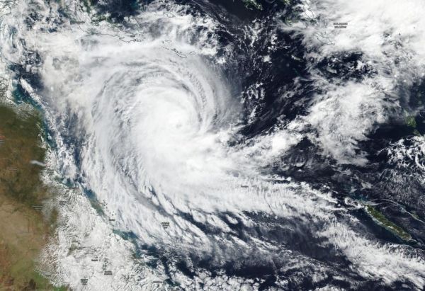
NASA-NOAA’s Suomi NPP satellite passed over Ann on May 13 and the Visible Infrared Imaging Radiometer Suite (VIIRS) instrument provided a visible image of the storm. The VIIRS image showed powerful thunderstorms wrapping around the center of circulation that appeared to be a cloud-filled eye. The VIIRS image also revealed a large thick band of thunderstorms extending from the center to the southeast, giving the appearance of a large tail.
Read more at NASA / Goddard Space Flight Center
Image: NASA-NOAA’s Suomi NPP satellite passed over the Southern Pacific Ocean and captured a visible image of Tropical Cyclone Ann on May 13. Ann was located in the Coral Sea, east of Queensland, Australia. Credit: NASA Worldview, Earth Observing System Data and Information System (EOSDIS).


