
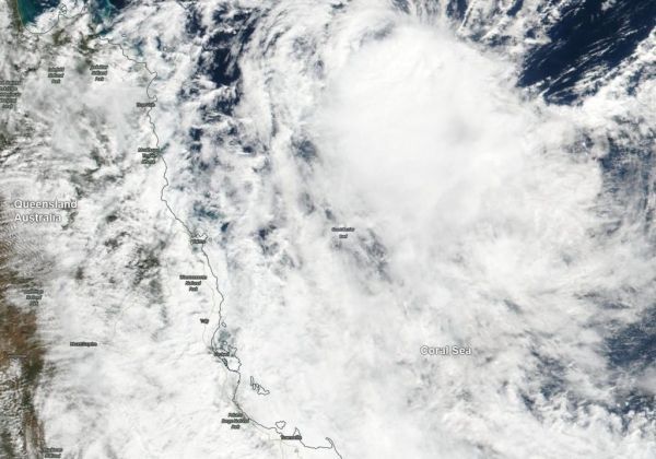
Australia’s world-famous Great Barrier Reef is located in the Coral Sea, east of Queensland and on May 14, Tropical Cyclone Ann was moving over it.
Australia’s world-famous Great Barrier Reef is located in the Coral Sea, east of Queensland and on May 14, Tropical Cyclone Ann was moving over it. From their orbit in space, NASA’s Terra and Aqua satellites passed over the Southern Pacific Ocean obtained visible and infrared imagery of the storm as it moved toward the Queensland coast.
The Great Barrier Reef is the world’s largest coral reef system. The Reef is made up of more than 2,900 individual reefs and 900 islands that cover more than stretching for over 1,429 miles (2,300 kilometers).
An infrared look at the tropical storm obtained by NASA’s Aqua satellite revealed where the strongest storms were located within Tropical Cyclone Ann on May 13 at 0341 UTC (May 12 at 11:41 p.m. EDT). The Atmospheric Infrared Sounder or AIRS instrument aboard NASA’s Aqua satellite analyzed cloud top temperatures and found cloud top temperatures of strongest thunderstorms as cold as or colder than minus 63 degrees Fahrenheit (minus 53 degrees Celsius) circling the center and in a large band of thunderstorms north of the center. Cloud top temperatures that cold indicate strong storms that have the capability to create heavy rain.
Read more at NASA / Goddard Space Flight Center
Image: On May 14, NASA’s Terra satellite provided a visible image of Tropical Cyclone Ann as it was moving over the Great Barrier Reef in the Coral Sea. CREDIT: NASA Worldview, Earth Observing System Data and Information System (EOSDIS)


