
A study conducted by scientists from Brazil, the United States and Portugal investigated the accuracy and consistency of different satellite data collections with regard to the location and size of burned areas in the Cerrado biome, the Brazilian savanna.
A study conducted by scientists from Brazil, the United States and Portugal investigated the accuracy and consistency of different satellite data collections with regard to the location and size of burned areas in the Cerrado biome, the Brazilian savanna.
The results, published in the International Journal of Applied Earth Observation and Geoinformation will help improve the output produced by Programa Queimadas, a program run by Brazil’s National Space Research Institute (INPE) to monitor wildfires and burns by satellite and to calculate and forecast forest fire risk.
The study was linked to the Brazilian Fire-Land-Atmosphere System (BrFLAS), a project supported by FAPESP. Its principal investigator was Renata Libonati, a professor at the Federal University of Rio de Janeiro (UFRJ) in Brazil, in collaboration with researchers at the University of Maryland (USA) and the University of Lisbon (Portugal). The study was also one of several projects conducted as follow ups to the master’s research of the first author Júlia Abrantes Rodrigues.
Several previous studies showed that fire – which can be used intelligently as part of a properly considered strategy with total area zoning and a rotating fire schedule – is indispensable to renewal the Cerrado (read more at agencia.fapesp.br/26064).
Read more at Fundação De Amparo à Pesquisa Do Estado De São Paulo
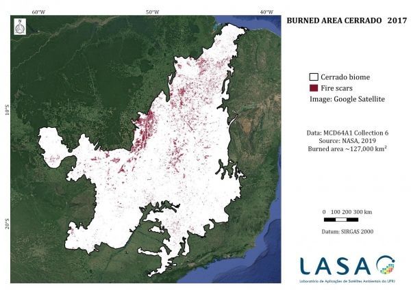
Image: The image produced by the scientists involved in the project shows fire scars throughout the Cerrado on the basis of 2017 data. (Credit:Renata Libonati et al.)


