
NASA’s Terra satellite showed Tropical Cyclone Vayu still lingering near the northwestern coast of India, and its cloud-filled eye remained offshore.
NASA’s Terra satellite showed Tropical Cyclone Vayu still lingering near the northwestern coast of India, and its cloud-filled eye remained offshore.
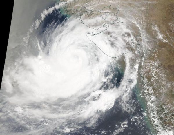
On June 14, 2019, t the Moderate Resolution Imaging Spectroradiometer or MODIS instrument aboard NASA’s Terra satellite provided a visible image of Tropical Cyclone Vayu located off western India’s Gujarat coast. Animated enhanced infrared satellite imagery revealed a compact area of asymmetric central deep convection (building thunderstorms) with well-organized spiral banding wrapping into a cloud-filled ragged eye.
JTWC forecasters noted that there are several things happening with the storm that is affecting the strength and shape of it. Dry air continues to feed into the storm, which prevents the development of thunderstorms (that make up the tropical cyclone). However, that is offset by low vertical wind shear (outside winds blowing at different speeds at different levels of the atmosphere that if strong enough, can blow a storm apart). Vayu is also moving through very warm waters, as warm as 30 to 31 degrees Celsius (86 to 87.8 degrees Fahrenheit) that is keeping the storm together. Tropical cyclones require sea surface temperatures of at least 80 degrees Fahrenheit (26.6 degrees Celsius) to maintain them. Warmer sea surface temperatures help keep storms together or give them fuel to strengthen further.
Read more at NASA/Goddard Space Flight Center
Image: On June 14, 2019, the MODIS instrument aboard NASA's Terra satellite provided a visible image of Tropical Cyclone Vayu off India's Gujarat coast, western India. (Credit: NASA Worldview, Earth Observing System Data and Information System (EOSDIS))


