
During the Height of the Cold War, a telescope-shaped American spy satellite code-named Hexagon circled the globe snapping high-resolution photographs of forests, mountains, and perhaps a few Russian military bases.
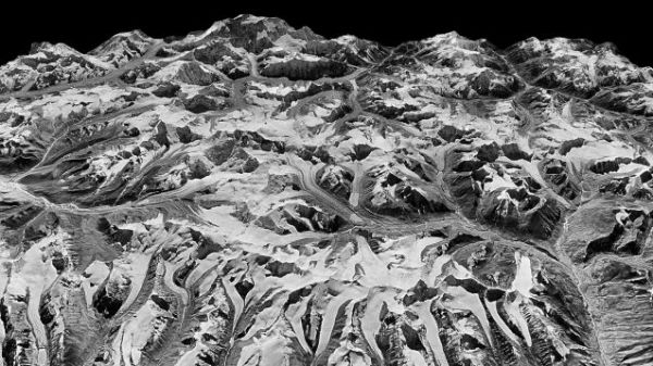
During the Height of the Cold War, a telescope-shaped American spy satellite code-named Hexagon circled the globe snapping high-resolution photographs of forests, mountains, and perhaps a few Russian military bases. From time to time, the satellite would eject metal canisters containing the film of the imagery. The canister would deploy its parachute, and high-flying spy planes would pick it up midair. Now, a team of scientists has stitched together these once-classified analog images to form a three-dimensional digital model of the Himalayas as they existed more than 40 years ago.
By comparing the model with images taken today, researchers found that the mountains’ glaciers are melting at double the rate since 2000 as during the period of 1976 to 2000, and that a warming climate is the culprit.
While scientists have documented the melting of individual glaciers in the Himalayas, this new study looks at a 1,250-mile-wide range across Nepal, Bhutan, India, and China, and reveals some disturbing news. “The fact we can look at ice losses over this long of a time scale and see most of the glaciers have lost similar amounts of ice really indicates there is one overarching factor causing this,” says Josh Maurer, a graduate student at Columbia University’s Lamont-Doherty Earth Observatory and author of a new study in the journal Science Advances. “Global temperature rise is the only one that makes sense.”
Read more at Yale Environment 360
Image: View of the Himalayas captured December 20, 1975 by a KH-9 HEXAGON spy satellite. NATIONAL RECONNAISSANCE OFFICE/U.S. GEOLOGICAL SURVEY


