
NASA’s Terra and Aqua satellites passed over the Eastern Pacific Ocean after Tropical Storm Barbara strengthened into the first hurricane of the season. Barbara intensified rapidly into a major hurricane.
NASA’s Terra and Aqua satellites passed over the Eastern Pacific Ocean after Tropical Storm Barbara strengthened into the first hurricane of the season. Barbara intensified rapidly into a major hurricane.
NOAA’s National Hurricane Center (NHC) noted that Barbara intensified early during the morning of July 2 and could strengthen a little more. Fortunately, Barbara is over 1,000 miles west of the southern tip of Baja California, and there are no coastal watches or warnings in effect.
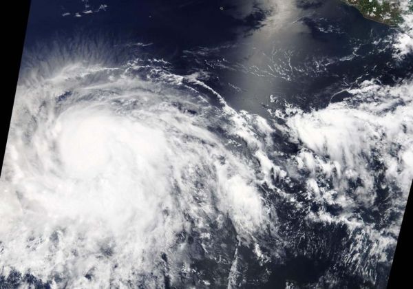
On July 2, the Moderate Resolution Imaging Spectroradiometer or MODIS instrument aboard NASA’s Terra satellite provided a visible image of Barbara that showed powerful thunderstorms circling an eye. Bands of thunderstorms wrapped into the center from the southern and eastern quadrants.
An infrared look by NASA’s Aqua satellite on July 2, at 5:17 a.m. EDT (0917 UTC revealed where the strongest storms were located within Hurricane Barbara. The Atmospheric Infrared Sounder or AIRS instrument aboard NASA’s Aqua satellite analyzed cloud top temperatures and found cloud top temperatures of strongest thunderstorms as cold as or colder than minus 81.6 degrees Fahrenheit (minus 63.1 degrees Celsius) circling the eye, which was seen in a lighter color in a false-colored NASA image. Cloud top temperatures that cold indicate strong storms that have the capability to create heavy rain.
Read more at: NASA
On July 2, 2019, the MODIS instrument aboard NASA's Terra satellite provided a visible image of Hurricane Barbara in the Eastern Pacific Ocean, now far from western Mexico. (Photo credit: NASA Worldview, Earth Observing System Data and Information System (EOSDIS))


