
Hurricane Barbara continued to track west through the Eastern Pacific Ocean when NASA-NOAA’s Suomi NPP satellite passed overhead on July 4.
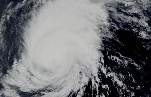
Hurricane Barbara continued to track west through the Eastern Pacific Ocean when NASA-NOAA’s Suomi NPP satellite passed overhead on July 4. Satellite imagery revealed clouds filling into Barbara’s eye as wind shear continued to weaken the storm and push the bulk of its clouds north of the center.
The Visible Infrared Imaging Radiometer Suite (VIIRS) instrument aboard Suomi NPP provided a visible image of the storm. The VIIRS image and microwave satellite imagery indicates that Barbara is being torn apart by winds outside or around the storm. In general, wind shear is a measure of how the speed and direction of winds change with altitude. The National Hurricane Center noted that the eyewall structure appears to be disintegrating and the low-level center is located to the south of the remaining strong thunderstorms.
There are several factors weakening the once Category 4 hurricane: increasing southwesterly wind shear, dry air moving into the storm and sapping the moisture and energy, and cooler sea surface temperatures that lay ahead of the storm as it continues moving west.
Read more at NASA / Goddard Space Flight Center
Photo: Hurricane Barbara continued to show an eye in visible imagery on July 4, 2019. NASA-NOAA’s Suomi NPP satellite passed over the Eastern Pacific Ocean and the VIIRS instrument aboard captured this image of the storm. Credit: NASA Worldview, Earth Observing System Data and Information System (EOSDIS)


