
Combining data from a new generation of satellites with a sophisticated algorithm, a new monitoring system developed by researchers at the University of Bath with NASA could be used by governments or developers to act as a warning system ensuring large-scale infrastructure projects are safe.
Combining data from a new generation of satellites with a sophisticated algorithm, a new monitoring system developed by researchers at the University of Bath with NASA could be used by governments or developers to act as a warning system ensuring large-scale infrastructure projects are safe.
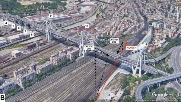
The team of experts led by NASA’s JPL and engineers from Bath verified the technique by reviewing 15 years of satellite imagery of the Morandi Bridge in Genoa, Italy, a section of which collapsed in August 2018, killing 43 people. The review, published in the journal Remote Sensing, showed that the bridge did show signs of warping in the months before the tragedy.
Dr Giorgia Giardina, Lecturer in the University’s Department of Architecture and Civil Engineering, said: “The state of the bridge has been reported on before, but using the satellite information we can see for the first time the deformation that preceded the collapse.
“We have proved that it is possible to use this tool, specifically the combination of different data from satellites, with a mathematical model, to detect the early signs of collapse or deformation.”
Read more at University of Bath
Image: The Morandi Bridge before its collapse. New satellite radar imaging can show the movement of structures with millimetre accuracy. (Credit: Remote Sensing)


