
Tropical Storm Barry formed during the morning of July 11 and the National Hurricane Center has issued several warnings and watches.
Tropical Storm Barry formed during the morning of July 11 and the National Hurricane Center has issued several warnings and watches. A Tropical Storm Warning is in effect from the mouth of the Pearl River to Morgan City. A Storm Surge Warning is in effect from the mouth of the Atchafalaya River to Shell Beach. A Storm Surge Watch is in effect for Shell Beach to the Mississippi/Alabama border and for the mouth of the Atchafalaya River to Intracoastal City.
There is also a hurricane and tropical storm watch in effect. A Hurricane Watch is in effect from the mouth of the Mississippi River to Cameron and a Tropical Storm Watch is in effect from east of the Mouth of the Pearl River to the Mississippi/Alabama border and for Lake Pontchartrain and Lake Maurepas including metropolitan New Orleans.
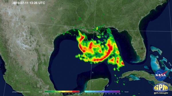
NASA and the Japan Aerospace Exploration Agency’s (JAXA) GPM Core Observatory passed over developing Tropical Depression 2 (which was upgraded to Tropical Storm Barry later in the morning) in the Gulf of Mexico the morning of July 11, 2019 at 8:26 a.m. CDT, capturing estimates of rainfall rates within the storm using GPM’s Microwave Imager (GMI) instrument.
Read more at: NASA
On July 11, 2019 at 8:26 a.m. CDT, GPM captured estimates of rainfall rates within the storm and found they exceeded 100 mm/hr (4


