
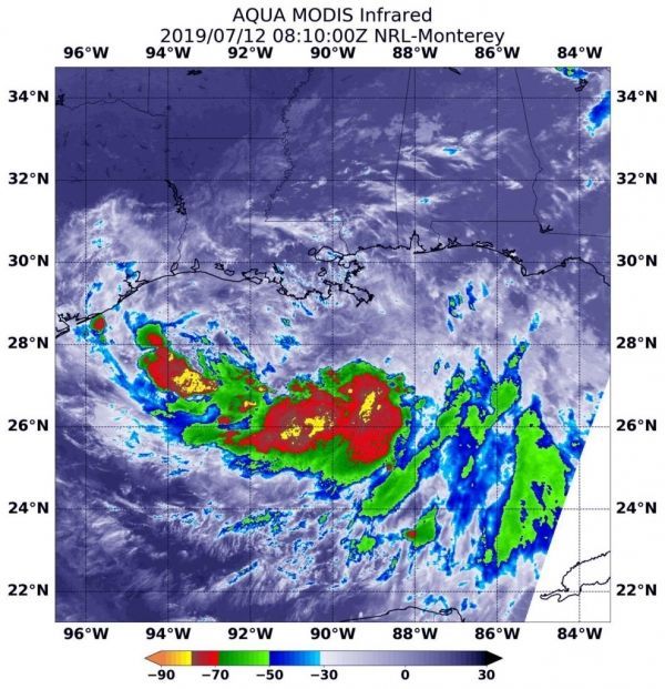
Infrared imagery from NASA’s Aqua satellite shows that Tropical Storm Barry doesn’t look like a typical strong tropical cyclone.
Infrared imagery from NASA’s Aqua satellite shows that Tropical Storm Barry doesn’t look like a typical strong tropical cyclone. Imagery revealed that Barry is elongated and the strongest storms were south of it’s stretched out center of circulation.
Warnings and Watches
At 8 a.m. EDT (1200 UTC) on Friday, July 12, NOAA’s National Hurricane Center (NHC) in Miami, Florida said that Barry is moving slowly to the west-northwest in the Gulf of Mexico, and south of the coast of southeastern Louisiana. NHC warns of dangerous storm surge, heavy rains, and wind conditions expected across the north-central Gulf coast.
Many warnings and watches are in effect as Barry hugs that northern Gulf coast, hammering the region. A Hurricane Warning is in effect from Intracoastal City to Grand Isle, Louisiana. A Tropical Storm Warning is in effect from the mouth of the Pearl River to Grand Isle, La. and for Lake Pontchartrain and Lake Maurepas including metropolitan New Orleans, and from Intracoastal City, Louisiana to Cameron, Louisiana.
Read more at NASA / Goddard Space Flight Center
Image: On July 12 at 4:10 a.m. EDT (0810 UTC) the MODIS instrument that flies aboard NASA’s Aqua satellite showed strongest storms in Tropical Storm Barry were south of the elongated center where cloud top temperatures were as cold as minus 70 degrees Fahrenheit (minus 56.6 Celsius). CREDIT: NASA/NRL


