
Tropical Storm Barry continued to linger in the Gulf of Mexico, generating a lot of heavy rainfall on Saturday, July 13, 2019.
Tropical Storm Barry continued to linger in the Gulf of Mexico, generating a lot of heavy rainfall on Saturday, July 13, 2019. Barry was just under the threshold of being classified a Category 1 hurricane and is expected to become one before landfall. NASA's Aqua satellite analyzed cloud top temperatures in the storm which gave an indication of the storm's strength.
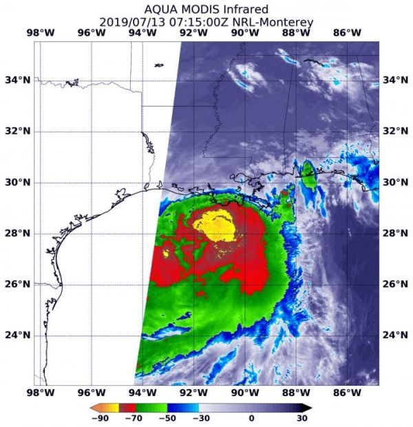
At 3:15 a.m. EDT (0715 UTC) on July 13, the MODIS or Moderate Resolution Imaging Spectroradiometer instrument aboard NASA's Aqua satellite looked at Tropical Strom Barry infrared light. MODIS found coldest cloud tops had temperatures near minus 80 degrees Fahrenheit (minus 62.2 degrees Celsius) south and east around a slightly more rounded center of the tropical storm. Storms with temperatures that cold are indicative of strong storms and have been shown to have the capability to generate heavy rainfall.
The satellite image revealed a large area of strong thunderstorms that cold, surrounded by an even larger area of thunderstorms with cloud tops just slightly less cold. At the time of the image, the largest area of strong storms still appeared to be mostly south of the center of circulation and over the Gulf of Mexico. That's because wind shear from the north-northwest is still battering the storm and pushing the strongest thunderstorms south and southeast of the center.
Read more at: NASA
At 3:15 a.m. EDT (0715 UTC) on July 13, the MODIS instrument aboard NASA's Aqua satellite looked at Tropical Storm Barry in infrared light. MODIS found coldest cloud tops (light green) had temperatures near minus 80 degrees Fahrenheit (minus 62.2 degrees Celsius) around the center of the tropical storm which was offshore from south central Louisiana. (Photo Credit: NASA/NRL)


