
Over the past 22 years, sea levels in the Arctic have risen an average of 2.2 millimeters per year.
Over the past 22 years, sea levels in the Arctic have risen an average of 2.2 millimeters per year. This is the conclusion of a Danish-German research team after evaluating 1.5 billion radar measurements of various satellites using specially developed algorithms.
"The Arctic is a hotspot of climate change," explains Prof. Florian Seitz of the German Geodetic Research Institute at the Technical University of Munich (TUM). "Due to rising temperatures, the glaciers of Greenland are receding. At the same time sea ice is melting. Every year, billions of liters of meltwater are released into the ocean.” The enormous volumes of fresh water released in the Arctic not only raise the sea level, they also have the potential to change the system of global ocean currents – and thus, our climate.
But how fast do sea levels rise? And precisely what effect does this have? To answer these questions, climatologists and oceanographers require specific measurements over as long a period as possible.
In a collaborative effort, researchers from the Technical University of Denmark (DTU) and from the TUM have now documented sea-level changes in the Arctic over more than two decades. "This study is based on radar measurements from space via so-called altimetry satellites and covers the period from 1991 to 2018. Thus, we have obtained the most complete and precise overview of the sea level changes in the Arctic Ocean to date. This information is important in terms of being able to estimate future sea levels associated with climate change,” says Stine Kildegaard Rose, Ph.D., researcher at DTU Space.
Read more at: Technical University of Munich
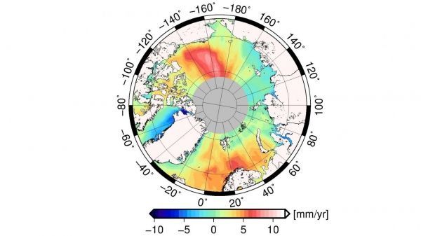
The map illustrates that the average change in the Arctic sea level varies regionally. (Photo Credit: DTU/DGFI-TUM)


