
NASA’s Aqua satellite took the temperature of Tropical Storm Flossie as it continued to strengthen and organize in the Eastern Pacific.
NASA’s Aqua satellite took the temperature of Tropical Storm Flossie as it continued to strengthen and organize in the Eastern Pacific.
Tropical Depression 7E formed in the Eastern Pacific Ocean on Sunday, July 28 about 580 miles (930 km) south-southwest of Manzanillo, Mexico. On July 29 at 5 a.m. EDT (0900 UTC), the depression strengthened into a tropical storm and was renamed Flossie.
Infrared light enables NASA to take the temperatures of clouds and thunderstorms that make up tropical cyclones. The stronger the storms are indicate that they extend high into the troposphere and have cold cloud top temperatures.
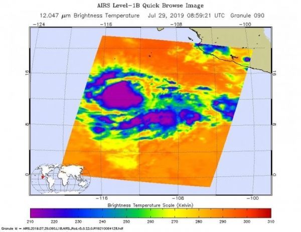
An infrared look at Flossie by NASA’s Aqua satellite on June 29, at 0459 UTC (0859 UTC) revealed where the strongest storms were located within the system. The Atmospheric Infrared Sounder or AIRS instrument aboard NASA’s Aqua satellite analyzed Flossie and found cloud top temperatures of strongest thunderstorms as cold as or colder than minus 63 degrees Fahrenheit (minus 53 degrees Celsius) circling the center. Cloud top temperatures that cold indicate strong storms that have the capability to create heavy rain.
Read more at NASA/Goddard Space Flight Center
Image: On June 29, 2019 at 0459 UTC (0859 UTC) the AIRS instrument aboard NASA's Aqua satellite analyzed cloud top temperatures of Tropical Storm Flossie in infrared light. AIRS found coldest cloud top temperatures (purple) of strongest thunderstorms were as cold as or colder than minus 63 degrees Fahrenheit (minus 53 degrees Celsius). (Credit: NASA JPL/Heidar Thrastarson)


