
Hurricane Erick has become the first tropical cyclone to enter the Central Pacific Ocean during the 2019 Hurricane Season and Hawaii is keeping an eye on the storm.
Hurricane Erick has become the first tropical cyclone to enter the Central Pacific Ocean during the 2019 Hurricane Season and Hawaii is keeping an eye on the storm. NASA’s Aqua satellite is also keeping eyes on Erick, too, and analyzed the water vapor content within the storm.
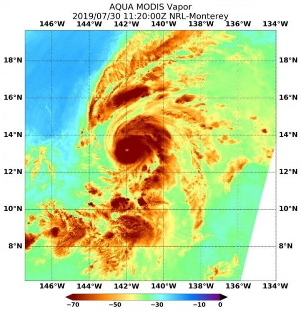
NASA’s Aqua satellite passed Hurricane Erick on July 30 at 7:20 a.m. EDT (1120 UTC) and the Moderate Resolution Imaging Spectroradiometer or MODIS instrument gathered water vapor content and temperature information. The MODIS image showed highest concentrations of water vapor and coldest cloud top temperatures were in a thick ring of storms around the newly developed eye and in a fragmented band of thunderstorms north-northwest of Erick’s center.
MODIS data also showed coldest cloud top temperatures were as cold as or colder than minus 70 degrees Fahrenheit (minus 56.6 degrees Celsius) in those storms. Storms with cloud top temperatures that cold have the capability to produce heavy rainfall. The circular eye was indicated by warmer temperatures near minus 30 degrees Fahrenheit (minus 34.4 degrees Celsius). Those warmer temperatures, although still very cold, mean that there are high clouds covering the eye. High cirrus clouds covering the eye mean that it would not yet be seen on visible satellite imagery.
Read more at NASA/Goddard Space Flight Center
Image: NASA's Aqua satellite passed over Hurricane Erick on July 30, 2019 at 7:20 a.m. EDT (1120 UTC) after it entered the Central Pacific Ocean. Aqua found highest concentrations of water vapor (dark brown) and coldest cloud top temperatures were around the eye. (Credit: NASA/NRL)


