
Tropical Storm Wipha formed quickly in the South China Sea.
Tropical Storm Wipha formed quickly in the South China Sea. It was affecting Hainan Island, China when NASA’s Aqua satellite passed overhead on July 31.
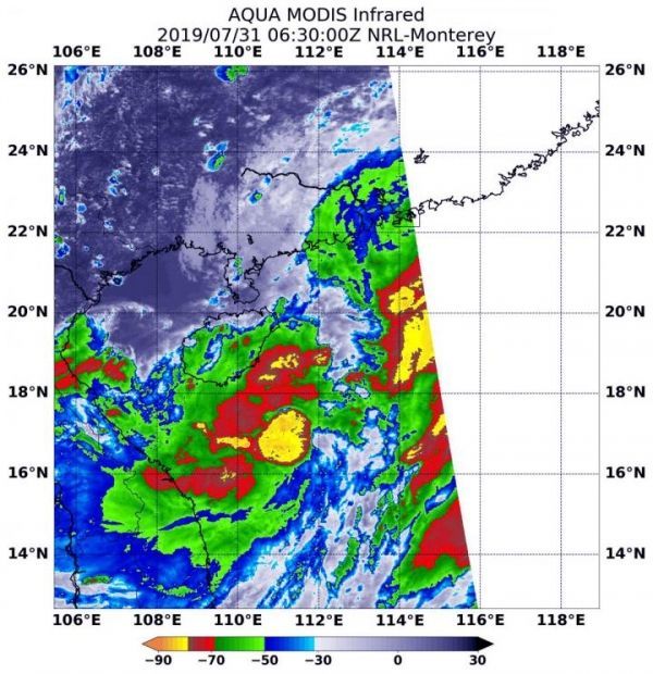
NASA’s Aqua satellite used infrared light to analyze the strength of storms and found the bulk of them in the southern quadrant. Infrared data provides temperature information, and the strongest thunderstorms that reach high into the atmosphere have the coldest cloud top temperatures.
ON July 31 at 2:30 a.m. EDT (0630 UTC), the Moderate Imaging Spectroradiometer or MODIS instrument that flies aboard NASA’s Aqua satellite gathered infrared data on Tropical Storm Wipha. Strong thunderstorms circled the center where cloud top temperatures were as cold as minus 80 degrees Fahrenheit (minus 62.2 Celsius). Those storms were over the South China Sea, just southeast of Hainan Island, China. Another area of storms that strong were in a fragmented band to the northeast of the center.
Read more at NASA/Goddard Space Flight Center
Image: On July 31, 2019 at 2:30 a.m. EDT (0630 UTC) the MODIS instrument that flies aboard NASA's Aqua satellite showed strongest storms in Tropical Storm Wipha were southeast of Hainan Island, China, in the South China Sea. Cloud top temperatures were as cold as minus 80 degrees Fahrenheit (minus 62.2 Celsius). (Credit: NASA/NRL)


