
Infrared imagery from NASA’s Aqua satellite revealed Tropical Storm Erick is being battered by wind shear, and that its strongest storms were south of the Big Island of Hawaii.
Infrared imagery from NASA’s Aqua satellite revealed Tropical Storm Erick is being battered by wind shear, and that its strongest storms were south of the Big Island of Hawaii. NOAA forecasters used other NASA satellites to find Erick’s center.
In the National Hurricane Center (NHC) Discussion of Erick on August 2 at 11 a.m. EDT (1500 UTC), Forecaster Jelsema noted that the NHC utilized data from two NASA satellites to find Erick’s center. The Discussion noted “Although the center was difficult to locate overnight due to high level cloud cover moving over the low-level center of circulation, a timely GPM (Global Precipitation Measurement mission) pass at 7:36 a.m. EDT (1136Z) and a Visible Infrared Imaging Radiometer Suite (VIIRS) pass at 7:40 a.m. EDT (1140Z) assisted in locating the center.” VIIRS is an instrument aboard NASA-NOAA’s Suomi NPP satellite.
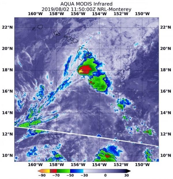
In addition, NASA’s Aqua satellite used infrared light to analyze the strength of storms and found the bulk of them in the southwestern quadrant of Erick, and south of the Big Island of Hawaii. Infrared data provides temperature information, and the strongest thunderstorms that reach high into the atmosphere have the coldest cloud top temperatures. Cloud top temperatures that cold indicate strong storms with the potential to generate heavy rainfall. Those strongest storms were south and southeast of the center of the elongated circulation.
Read more at NASA/Goddard Space Flight Center
Image: On August 2, 2019 at 7:50 a.m. EDT (1150 UTC) the MODIS instrument that flies aboard NASA's Aqua satellite showed strongest storms in Tropical Storm Erick were south of the Big Island of Hawaii, and west of the center, where cloud top temperatures were as cold as minus 80 degrees Fahrenheit (minus 62.2 Celsius). (Credit: NASA/NRL)


