
NASA’s Aqua satellite passed over the Korea Strait and found the center of Tropical Storm Francisco in the middle of it.
NASA’s Aqua satellite passed over the Korea Strait and found the center of Tropical Storm Francisco in the middle of it. The AIRS instrument aboard took the temperature of its cloud tops to estimate storm strength and found strong storms over two countries.
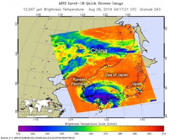
The Korea Strait is a located between South Korea and Japan. It connects the East China Sea, the Yellow Sea and the Sea of Japan in the northwest Pacific Ocean.
NASA’s Aqua satellite passed over Francisco on Aug. 6, at 1217 a.m. EDT (0417 UTC). The Atmospheric Infrared Sounder or AIRS instrument aboard NASA’s Aqua satellite analyzed Francisco in infrared light and found cloud top temperatures of strongest thunderstorms as cold as or colder than minus 63 degrees Fahrenheit (minus 53 degrees Celsius) were wrapping around the low-level center from west to north to east. Cloud top temperatures that cold indicate strong storms that have the capability to create heavy rain. Those strong storms were affecting southern South Korea and southern Japan. The southern side of the storm appeared to have few storms.
Read more at NASA / Goddard Space Flight Center
Image: On Aug. 6, at 1217 a.m. EDT (0417 UTC). the AIRS instrument aboard NASA’s Aqua satellite analyzed cloud top temperatures of Tropical Storm Francisco in infrared light. AIRS found coldest cloud top temperatures (purple) of strongest thunderstorms were as cold as or colder than minus 63 degrees Fahrenheit (minus 53 degrees Celsius). CREDIT: NASA JPL/Heidar Thrastarson


