
NASA’s Aqua satellite provided forecasters at the Joint Typhoon Warning Center with infrared data and cloud top temperature information for Tropical Storm Krosa as it was making landfall in southern Japan.
NASA’s Aqua satellite provided forecasters at the Joint Typhoon Warning Center with infrared data and cloud top temperature information for Tropical Storm Krosa as it was making landfall in southern Japan.
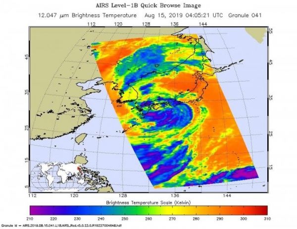
Cloud top temperatures provide information to forecasters about where the strongest storms are located within a tropical cyclone. The stronger the storms, the higher they extend into the troposphere, and they have the colder cloud temperatures. NASA’s Aqua satellite took Tropical Storm Krosa’s cloud top temperatures to get that information and found the strongest storms south of the storm’s center.
NASA’s Aqua satellite analyzed the storm on Aug. 15, at 12:05 a.m. EDT (0405 UTC) using the Atmospheric Infrared Sounder or AIRS instrument. AIRS found coldest cloud top temperatures as cold as or colder than minus 63 degrees Fahrenheit (minus 53 degrees Celsius) south of the center and over the waters of the Northwestern Pacific Ocean. Cloud top temperatures that cold indicate strong storms that have the capability to create heavy rain.
Read more at: NASA/Goddard Space Flight Center
On Aug. 15, 2019 at 12:05 a.m. EDT (0405 UTC) the AIRS instrument aboard NASA's Aqua satellite analyzed cloud top temperatures of Tropical Storm Krosa in infrared light. AIRS found coldest cloud top temperatures (purple) of strongest thunderstorms were as cold as or colder than minus 63 degrees Fahrenheit (minus 53 degrees Celsius) south of the center. (Photo Credit: NASA JPL/Heidar Thrastarson)


