
The middle and lower reaches of the Yangtze River Basin (YRB-ML) generally enter the Mei-yu season in the period from mid-June to mid-July.
The middle and lower reaches of the Yangtze River Basin (YRB-ML) generally enter the Mei-yu season in the period from mid-June to mid-July. During the Mei-yu season, the YRB-ML often experiences heavy rainfall due to convective systems, which occur and propagate eastward repeatedly in a narrow latitudinal corridor, thereby enhancing their capacity for causing catastrophic flooding.
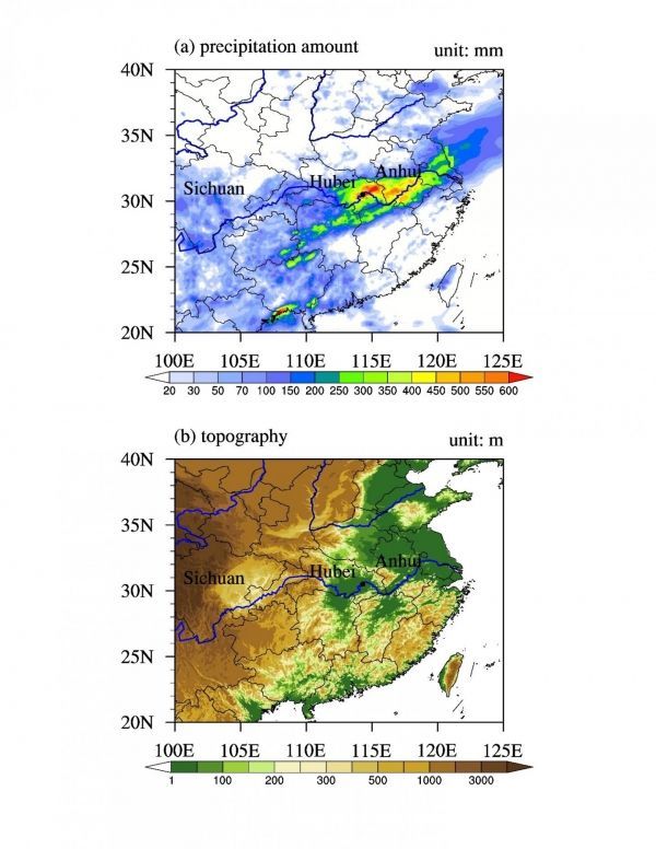
In the summer of 2016, a particularly heavy rainfall event hit the YRB-ML during the period from 30th June to 6th July, with a record-breaking rainfall amount of 582.5 mm in Wuhan (30.60°N, 114.30°E; the provincial capital city of Hubei province, please see Figure 1). Due to its relatively lower topography compared to surrounding regions, Wuhan suffered a terrific flooding disaster which inundated many roads, trapping residents inside vehicles and buildings. Overall, the event left about 237 dead and 93 missing, affected more than ten provinces and resulted in over $22 billion in damage, making it a high-impact weather event of international significance.
Previous study using global model at relatively coarse resolution can generally simulate the spatial distribution of accumulated precipitation amount of this heavy rainfall event, but considerable model biases still exist. Recently, under the Climate Science for Service Partnership (CSSP China) (http://www.lasg.ac.cn/cssp/index.html), supported by the UK-China Research and Innovation Partnership Fund, researchers from the Institute of Atmospheric Physics at Chinese Academy of Sciences, have collaborated with colleagues from the Chinese Academy of Meteorological Sciences at China Meteorological Administration, and the UK Met Office, to investigate this event at both global and regional scale by using the Met Office Unified Model (MetUM). Especially, they used high-resolution convection-permitting model (CPM) at regional scale.
Read more at Institute of Atmospheric Physics, Chinese Academy of Sciences
Image: (a) Accumulated rainfall amount (unit: mm) from 30th June to 6th July, 2016. (b) Topography distribution (unit: m) over eastern China. Here the text "Sichuan", "Hubei" and "Anhui" indicates the location of Sichuan, Hubei and Anhui province, respectively. The black dot in (a) and (b) indicates Wuhan city, the provincial capital of Hubei province. (Credit: Puxi Li)


