
As Hurricane Dorian was upgraded to a Category 3 hurricane on the Saffir-Simpson Hurricane Wind Scale, NASA’s fleet of satellites were gathering data during the day to assist weather forecasters and scientists.
As Hurricane Dorian was upgraded to a Category 3 hurricane on the Saffir-Simpson Hurricane Wind Scale, NASA’s fleet of satellites were gathering data during the day to assist weather forecasters and scientists. At 2:oo pm EDT the National Hurricane Center (NHC) posted a supplemental advisory. NHC reports that “extremely dangerous Hurricane Dorian poses a significant threat to Florida and the northwestern Bahamas. The Hurricane Hunter plane finds Dorian is now a major hurricane.”
NASA’s Global Precipitation Measurement mission satellite uses its IMERG algorithm with data from a fleet of satellites to provide global estimates of the precipitation within the storm every 30 minutes. This map is showing the estimates early on the morning of August 30 prior to Dorian becoming a Category 3 storm.
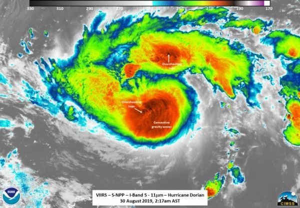
NOAA-NASA’s Suomi NPP satellite uses its complement of instruments onboard to dissect storms and provide information on many different aspects of the hurricane including storm strength, cloudtop temperature, circulation, and rainfall, among others, within the structure of the storm. The next three images are all from the Suomi NPP satellite and its instruments which help scientists figure out the intensity of the storm and help predict where it will ultimately end up.
Read more at NASA/Goddard Space Flight Center
Image: NASA/NOAA's Suomi NPP satellite was in an ideal position for observing Dorian at 0617 UTC (2:17 am EDT) at an almost nadir view (right over the storm). The infrared imagery showed a somewhat circular storm, though a bit lopsided. However, the convection was strong enough to result in several overshooting tops and tropospheric gravity waves are atmospheric waves (in this observation from the troposphere) that are produced by strong thunderstorms near the eye and radiate outward in expanding spirals giving forecasters and scientists a good indicator of the strength of the storm. This top-down view of Dorian allowed the microwave sounder to observe the inner structure of the storm. (Credit: NASA/NOAA/UWM-SSEC-CIMSS/William Straka III)


