
Another Atlantic Ocean basin depression formed while Hurricane Dorian is still wreaking havoc on the Bahamas and affecting the southeastern U.S. Infrared imagery from NASA’s Aqua satellite shows that Tropical Depression 7 in the western Gulf of Mexico has developed powerful thunderstorms with heavy rain capabilities.
Another Atlantic Ocean basin depression formed while Hurricane Dorian is still wreaking havoc on the Bahamas and affecting the southeastern U.S. Infrared imagery from NASA’s Aqua satellite shows that Tropical Depression 7 in the western Gulf of Mexico has developed powerful thunderstorms with heavy rain capabilities. That potential for heavy rainfall includes southern Texas and northeastern Mexico.
NASA conducts research on tropical cyclones and provides various data to forecasters at NOAA’s National Hurricane Center (NHC) to consider in their forecasts.
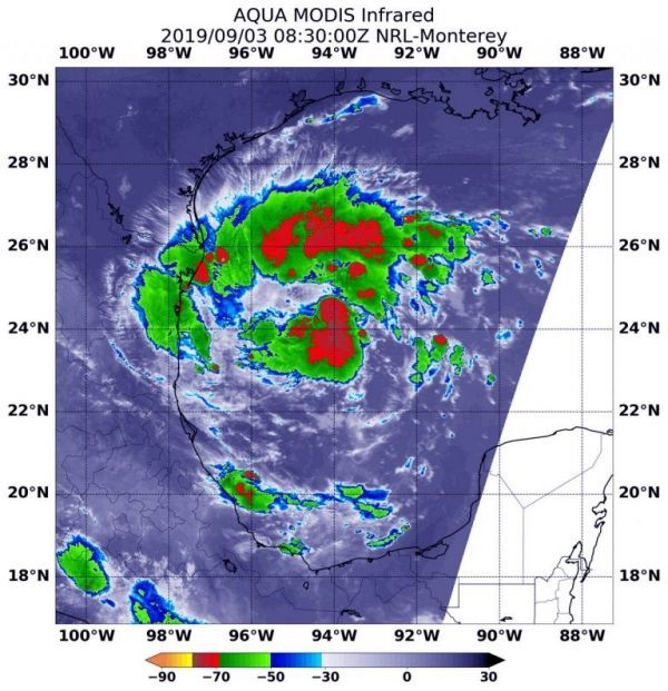
NASA’s Aqua satellite used infrared light to analyze the strength of storms in Tropical Depression 7 and found strongest storms in fragmented bands of thunderstorms north and south of the center. The westernmost extent of those strong storms were already affecting the extreme northeastern coast of Mexico. Infrared data provides temperature information, and the strongest thunderstorms that reach high into the atmosphere have the coldest cloud top temperatures.
Read more at NASA / Goddard Space Flight Center
Image: On Sept. 3 at 4:30 a.m. EDT (0830 UTC) the MODIS instrument that flies aboard NASA’s Aqua satellite showed strongest storms (red) in fragmented thunderstorms around the center of Tropical Depression 7 in the western Gulf of Mexico. There, cloud top temperatures were as cold as minus 70 degrees Fahrenheit (minus 56.6 Celsius). Credit: NASA/NRL


