
Hurricane Dorian dropped excessive rainfall on the Bahamas and NASA calculated the rainfall the storm generated.
Hurricane Dorian dropped excessive rainfall on the Bahamas and NASA calculated the rainfall the storm generated.
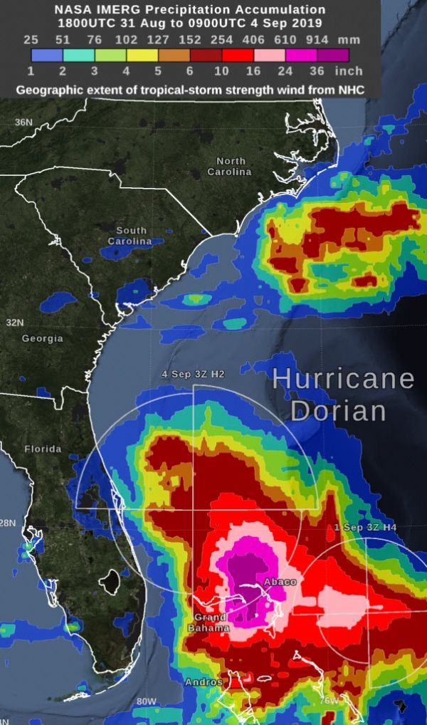
“By Wednesday morning, September 4, the rain accumulation from Hurricane Dorian exceeded 36 inches in an area that included parts of Grand Bahama Island and Abaco Island,” said Owen Kelley, researcher at NASA Goddard. “By that time, the Dorian’s center was north of the Bahamas and was moving further north, approximately parallel to Florida’s east coast.”
NASA Estimating Rainfall
NASA has the ability to peer under the clouds of a tropical cyclone and estimate the rainfall rates occurring in a storm or how much rain has fallen. Rainfall imagery was generated using the Integrated Multi-satEllite Retrievals for GPM or IMERG product at NASA’s Goddard Space Flight Center in Greenbelt, Maryland. These near-realtime rain estimates come from the NASA IMERG algorithm, which combines observations from a fleet of satellites in the GPM or Global Precipitation Measurement mission constellation of satellites, and is calibrated with measurements from the GPM Core Observatory as well as rain gauge networks around the world. The measurements are done in near-real time, to provide global estimates of precipitation every 30 minutes.
Read more at NASA / Goddard Space Flight Center
Image: This image shows NASA IMERG estimated rainfall accumulations for the region of the Bahamas affected by Hurricane Dorian from Aug. 31 to Sept. 4. The imagery shows rainfall exceeded 36 inches in an area that included parts of Grand Bahama Island and Abaco Island. Credit: NASA Goddard


