
NASA’s Aqua satellite provided forecasters at the National Hurricane Center with infrared data and cloud top temperature information for Tropical Storm Fernand as it was making landfall in northeastern Mexico.
NASA’s Aqua satellite provided forecasters at the National Hurricane Center with infrared data and cloud top temperature information for Tropical Storm Fernand as it was making landfall in northeastern Mexico. Those temperatures indicated Fernand’s rainmaking capabilities. The infrared data also showed wind shear was affecting the storm.
NASA researches tropical cyclones and infrared data is one of the ways NASA uses. Cloud top temperatures provide information to forecasters about where the strongest storms are located within a tropical cyclone. The stronger the storms, the higher they extend into the troposphere, and they have the colder cloud temperatures.
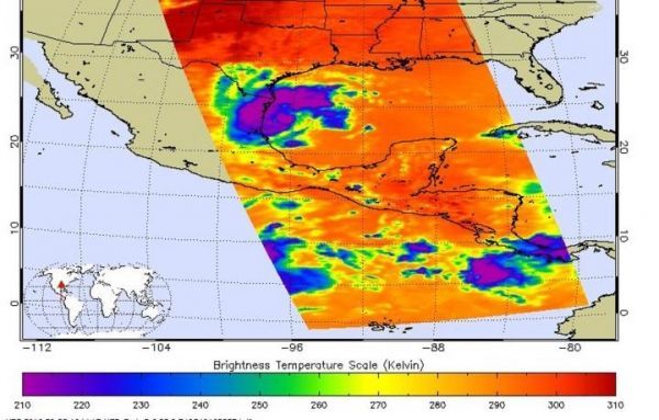
NASA’s Aqua satellite analyzed the storm on Sept. 3, at 5:23 a.m. EDT (0923 UTC) using the Atmospheric Infrared Sounder or AIRS instrument. AIRS found coldest cloud top temperatures as cold as or colder than minus 63 degrees Fahrenheit (minus 53 degrees Celsius) around the center and in a thick band of thunderstorms over northeastern Mexico. NASA research has shown that cloud top temperatures that cold indicate strong storms that have the capability to create heavy rain.
That heavy rainfall potential is apparent in the warnings posted today. In northeastern Mexico, from Tamaulipas and Central/Southern Nuevo Leon, 6 to 12 inches of rain are possible with isolated 18 inches, highest along the immediate Gulf Coast and in the Sierra Madre Oriental. This rainfall may cause life-threatening flash floods and mudslides. Areas from Northern Nuevo Leon and Southern Coahuila can expect 3 to 6 inches. The south Texas and the lower Texas coast can also expect 2 to 4 inches, with isolated totals to 6 inches. In addition, a tornado or two are possible across far South Texas through this evening.
Read more at NASA/Goddard Space Flight Center
Image: On Sept. 3, at 5:23 a.m. EDT (0923 UTC) the AIRS instrument aboard NASA's Aqua satellite analyzed cloud top temperatures of Tropical Storm Fernand in infrared light. AIRS found coldest cloud top temperatures (purple) of strongest thunderstorms were as cold as or colder than minus 63 degrees Fahrenheit (minus 53 degrees Celsius) around the center and in a thick band of thunderstorms over northeastern Mexico. (Credit: NASA JPL/Heidar Thrastarson)


