
Tropical Storm 14W has been moving through the Northwestern Pacific Ocean for several days and has now been renamed Faxai.
Tropical Storm 14W has been moving through the Northwestern Pacific Ocean for several days and has now been renamed Faxai. NASA’s Aqua satellite passed over the newly renamed storm and took the temperature of Faxai’s clouds and storms.
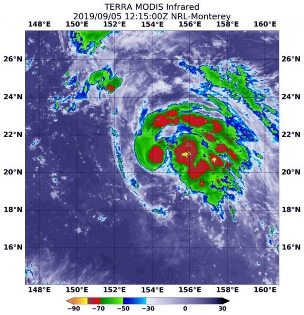
NASA’s Terra satellite used infrared light to analyze the strength of storms in the remnants of Tropical Storm Faxai. Infrared data provides temperature information, and the strongest thunderstorms that reach high into the atmosphere have the coldest cloud top temperatures.
On Sept. 5 at 8:15 a.m. EDT (1215 UTC), the Moderate Imaging Spectroradiometer or MODIS instrument that flies aboard NASA’s Terra satellite found strongest thunderstorms had cloud top temperatures as cold as or colder than minus 70 degrees Fahrenheit (minus 56.6 Celsius). Those temperatures were in cloud tops of storms around the low-level center of circulation and in a thick band of thunderstorms that wrapped around the storm from west to north to east. Cloud top temperatures that cold indicate strong storms with the potential to generate heavy rainfall.
Read more at NASA / Goddard Space Flight Center
Image: On Sept. 5 at 8:15 a.m. EDT (1215 UTC), the MODIS instrument that flies aboard NASA’s Aqua satellite showed strongest storms around Faxai’s center and in a curved band of thunderstorms from west to north to east. In those areas, cloud top temperatures were as cold as minus 70 degrees Fahrenheit (minus 56.6 Celsius). Credit: NASA/NRL


