
As the Bahamas continue to recover from Category 5 hurricane Dorian, a new developing tropical cyclone is bringing additional rainfall to an already soaked area.
As the Bahamas continue to recover from Category 5 hurricane Dorian, a new developing tropical cyclone is bringing additional rainfall to an already soaked area.
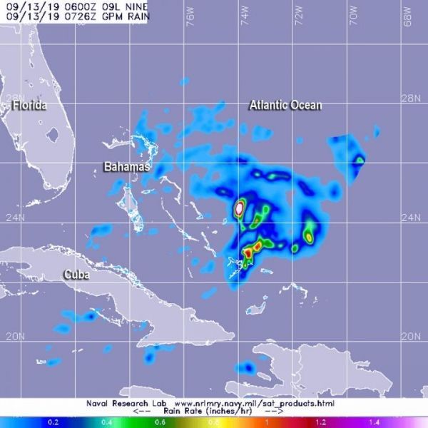
The Global Precipitation Measurement mission or GPM core satellite provided a look at those rainfall rates occurring in Potential Tropical Cyclone Nine, located over the Bahamas.
Potential Tropical Cyclone 9 developed around 5 p.m. EDT on Thursday, Sept. 12. At 11 a.m. EDT on Sept. 13, the depression triggered watches and warnings from NOAA’s National Hurricane Center. A Tropical Storm Warning is in effect for the northwestern Bahamas excluding Andros Island and a Tropical Storm Watch is in effect from Jupiter Inlet to the Flagler-Volusia County line, Fla.
Watches and warnings are already in effect. A Tropical Storm Warning is in effect for the northwestern Bahamas excluding Andros Island and a Tropical Storm Watch is in effect from Jupiter Inlet to Flagler-Volusia County line, Fla.
Read more at NASA/Goddard Space Flight Center
Image: The GPM core satellite passed over developing Potential Tropical Cyclone 9 on Sept. 13 at 2:26 a.m. EDT (0726 UTC). GPM found the heaviest rainfall (pink) northwest of the center where it was falling at a rate of over 40 mm (about 1.6 inch) per hour. Lighter rainfall rates (yellow and blue) were measured throughout the rest of the storm. (Credit: NASA/JAXA/NRL)


