
When the Global Precipitation Measurement mission or GPM core satellite passed over the Eastern Pacific Ocean, it flew over the eastern side of Tropical Storm Mario and measured rainfall.
When the Global Precipitation Measurement mission or GPM core satellite passed over the Eastern Pacific Ocean, it flew over the eastern side of Tropical Storm Mario and measured rainfall.
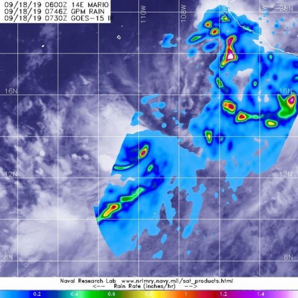
The GPM’s core satellite passed over Mario on Sept. 18 at 3:46 a.m. EDT (0746 UTC). GPM found the heaviest rainfall in the southeastern side of the storm falling at a rate of over 36 mm (about 1.4 inch) per hour. Lighter rainfall was measured throughout the rest of the east and southern quadrants and band of thunderstorms south of center. Forecasters at NOAA’s National Hurricane Center or NHC incorporate the rainfall data into their forecasts.
Mario formed on Sept. 17 as Tropical Depression 14E and six hours later at 6 p.m. EDT, it became a tropical storm.
At 11 a.m. EDT (1500 UTC), NHC forecasters said the center of Tropical Storm Mario was located near latitude 14.5 degrees north and longitude 111.0 degrees west. Mario is far from land, so there are no coastal warnings or watches in effect. Mario is centered about 585 miles (940 km) south of the southern tip of Baja California, Mexico.
Read more at NASA/Goddard Space Flight Center
Image: The GPM core satellite passed over developing Tropical Storm Mario in the eastern Pacific Ocean on Sept. 18, 2019 at 3:46 a.m. EDT (0746 UTC) and found the heaviest rainfall (pink) in the southeastern side of the storm falling at a rate of over 36 mm (about 1.4 inch) per hour. GPM data was overlaid on cloud imagery from NOAA's GOES-West satellite. (Credit: NASA/JAXA/NRL)


