
NASA’s Aqua Satellite provided data on Major Hurricane Humberto that revealed its structure was changing as it was moving through the North Atlantic Ocean and past Bermuda.
NASA’s Aqua Satellite provided data on Major Hurricane Humberto that revealed its structure was changing as it was moving through the North Atlantic Ocean and past Bermuda.
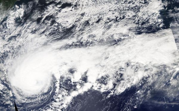
On Sept. 18 at 12:30 p.m. EDT, the Moderate Imaging Spectroradiometer or MODIS instrument that flies aboard NASA’s Aqua satellite provided visible data on Humberto and measured clouds heights and temperatures that indicated a shift in the storm.
The visible image revealed powerful thunderstorms circled the center and a large band stretched hundreds of miles east. Additional data showed the highest cloud tops, higher than 12,000 meters (7.65 miles) were located mostly south and southwest of the eye, although a small area circled the eye. Those were the most powerful storms within Humberto. Aqua research data also found that cloud top temperatures were as cold as or colder than 200 Kelvin (minus 99.6 degrees Fahrenheit/minus 73.1 degrees Celsius) around in those storms. NASA research has shown that cloud top temperatures that cold have the capability to generate heavy rainfall.
Read more at: NASA/Goddard Space Flight Center
On Sept. 18, the MODIS instrument that flies aboard NASA's Aqua provided a visible image of Hurricane Humberto north of Bermuda. Powerful thunderstorms circled the center and a large band stretched hundreds of miles east. Aqua cloud height and temperature data revealed Humberto was taking on an extra-tropical hybrid structure. (Photo Credit: NASA Worldview, Earth Observing System Data and Information System EOSDIS)


