
Tropical Storm Tapah formed quickly in the northwestern Pacific Ocean and as it was strengthening from a depression to a tropical storm, the Global Precipitation Measurement mission or GPM core satellite passed overhead from its orbit in space and measured rainfall rates throughout the storm.
Tropical Storm Tapah formed quickly in the northwestern Pacific Ocean and as it was strengthening from a depression to a tropical storm, the Global Precipitation Measurement mission or GPM core satellite passed overhead from its orbit in space and measured rainfall rates throughout the storm.
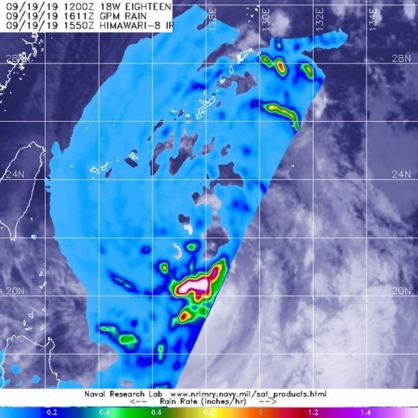
NASA has the unique capability of peering under the clouds in storms and measuring the rate in which rain is falling. The GPM’s core satellite passed over Tropical Storm Tapah in the northwestern Pacific Ocean on Sept. 16 at 12:11 p.m. EDT (1611 UTC).
GPM found the heaviest rainfall around the storm’s center, where it was falling at a rate of as much as 1.6 inches (40 mm) per hour. Forecasters at the Joint Typhoon Warning Center incorporate the rainfall data into their forecasts.
Read more at NASA / Goddard Space Flight Center
Image: The GPM core satellite passed over strengthening Tropical Storm Tapah in the northwestern Pacific Ocean on Sept. 16 at 12:11 p.m. EDT (1611 UTC) and found the heaviest rainfall (pink) falling at as much as 1.6 inches (40 mm) per hour. Credit: NASA/JAXA/NRL


