
Tropical Storm Tapah had taken on an elongated shape as it moved through the Sea of Japan, between South Korea and Japan.
Tropical Storm Tapah had taken on an elongated shape as it moved through the Sea of Japan, between South Korea and Japan. When the Global Precipitation Measurement mission or GPM core satellite passed over Tapah, it measured rainfall as the storm was becoming extra-tropical.
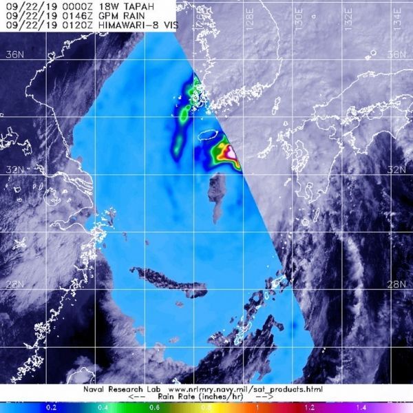
GPM passed over Tapah on Sept. 22 at 0000 UTC (Sept. 21 at 8 p.m. EDT). GPM found the heaviest rainfall in the northeastern side of the storm, where it was falling at a rate of over 36 mm (about 1.4 inch) per hour. Heavy rainfall was also visible in a band of thunderstorms feeding into the center from the northeastern quadrant where rain was falling at a rate of 25 mm (1 inch) per hour. Rainfall around the rest of the storm was light. The storm also appeared elongated in GPM imagery which is an indication of a storm becoming extra-tropical.
That means that a tropical cyclone has lost its “tropical” characteristics. NOAA’s National Hurricane Center defines “extra-tropical” as a transition that implies both poleward displacement (meaning it moves toward the north or south pole) of the cyclone and the conversion of the cyclone’s primary energy source from the release of latent heat of condensation to baroclinic (the temperature contrast between warm and cold air masses) processes. It is important to note that cyclones can become extratropical and still retain winds of hurricane or tropical storm force.
Read more at NASA’s Goddard Space Flight Center
Image: The GPM core satellite passed over transitioning Tropical Storm Tapah in the northwestern Pacific Ocean on Sept. 22 at 8:00 p.m. EDT (0000 UTC) and found the heaviest rainfall (pink) in the northeastern side of the storm falling at a rate of over 36 mm (about 1.4 inch) per hour. (Credit: NASA/JAXA/NRL)


