
Satellite imagery can be used to peer inside a storm as well as assess the storm’s outside shape to give forecasters understanding of what’s happening to it.
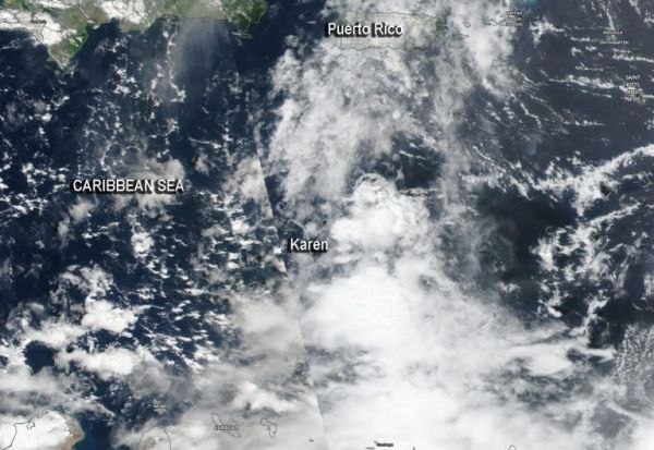
Satellite imagery can be used to peer inside a storm as well as assess the storm’s outside shape to give forecasters understanding of what’s happening to it. NASA-NOAA’s Suomi NPP satellite provided forecasters with a visible image of a less-organized Karen after it moved into the Caribbean Sea and encountered wind shear.
On Sunday, Sept. 22 at 5 a.m. EDT, NOAA’s National Hurricane Center said that Tropical Storm Karen formed just east of the Windward Islands. Twelve hours later, it had moved into the Caribbean Sea.
The shape of a tropical cyclone provides forecasters with an idea of its organization and strength. Imagery from Suomi NPP showed Karen had become less organized after it moved west from the Atlantic Ocean into the southeastern Caribbean Sea.
When outside winds batter a storm, it can change the shape of it and push much of the associated clouds and rain to one side of it. That’s what wind shear does. Karen encountered northeasterly wind shear when it moved into the Caribbean Sea and those winds continued to affect Karen on Sept. 23.
Read more at NASA / Goddard Space Flight Center
Image: NASA-NOAA’s Suomi NPP satellite passed over Tropical Storm Karen in the Caribbean Sea. Credit: NASA Worldview, Earth Observing System Data and Information System (EOSDIS)


