
NASA-NOAA’s Suomi NPP satellite imagery revealed that Tropical Storm Kiko had a tight circulation center.
NASA-NOAA’s Suomi NPP satellite imagery revealed that Tropical Storm Kiko had a tight circulation center.
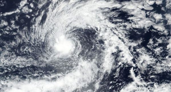
The Visible Infrared Imaging Radiometer Suite (VIIRS) instrument aboard Suomi NPP provided a visible image of Kiko on Sept. 22 that revealed the storm consisted of a tight circulation of low clouds with intermittent bursts of deep convection. The VIIRS image showed some powerful storms circled the low-level center and a large band of thunderstorms were located over the northern quadrant of the storm.
By early on Sept. 23, Kiko’s structure had improved on satellite imagery.
NOAA’s National Hurricane Center or NHC said, “At 11 a.m. EDT (1500 UTC) on Sept. 23 the center of Tropical Storm Kiko was located near latitude 15.7 north, longitude 135.8 west.
Read more at NASA / Goddard Space Flight Center
Image: NASA-NOAA’s Suomi NPP satellite passed over Tropical Storm Kiko on Sept.22 and revealed a tight circular area with some powerful storms around the low-level center. The image showed bands of thunderstorms were located over the northern quadrant of the storm. Credit: NASA Worldview, Earth Observing System Data and Information System (EOSDIS)


