
This week NOAA added a new model to its suite of tools designed to help the nation deal with space weather events.
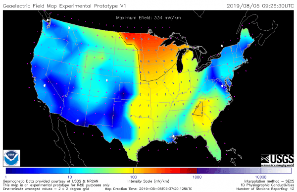
This week NOAA added a new model to its suite of tools designed to help the nation deal with space weather events. The NOAA-U.S. Geological Survey (USGS) Geoelectric Field Model calculates regional electric field levels in the U.S. caused by disturbances in Earth’s magnetic field from geomagnetic storms. The near real-time data indicates the level of space weather impact affecting the electrical power grid to help operators mitigate effects on critical infrastructure.
“We are always looking for ways to improve our forecasts and provide better decision support to our partners,” said Clinton Wallace, director, Space Weather Prediction Center (SWPC), a division of the National Weather Service. “The Geoelectric Field Model will allow us to deliver regional space-weather impact information for the first time. Power grid operators will now be able to quickly understand who in the United States will be affected by space weather, which was a critical missing piece of information.”
In the event of a coronal mass ejection, or CME, directed at Earth, SWPC forecasters will issue a warning using NOAA Space Weather Scales once the CME is detected on satellites stationed at the Lagrange Point One (L1), one million miles from Earth. These measurements at L1 provide key information on how intense the geomagnetic storm is likely to be, but until now, a critical piece of impact information was missing – which parts of the United States will be affected.
Continue reading at NOAA.
Image via NOAA.


