
Tropical Storm Karen has crossed over Puerto Rico and into the western Atlantic Ocean.
Tropical Storm Karen has crossed over Puerto Rico and into the western Atlantic Ocean. Early on Sept. 25 when Global Precipitation Measurement mission or GPM core satellite passed overhead, the satellite found heavy rain occurring over the territory.
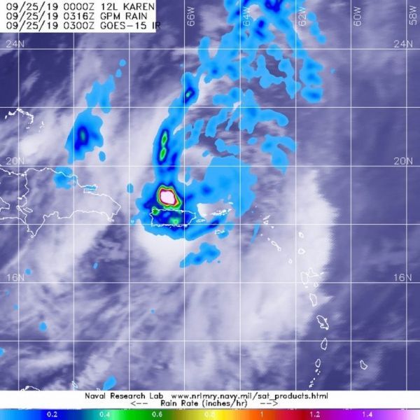
The GPM’s core satellite passed over Tropical Storm Karen on Sept. 25 at 0316 UTC (Sept. 24 at 11:16 p.m. EDT). GPM found heavy rain falling at a rate greater than 1.6 inches (40 millimeters) southwest of Karen’s center over the Atlantic Ocean and just north of central Puerto Rico. Heavy rain was also falling at more than 1 inch (25 mm) per hour over much of Puerto Rico and extended far to the north of Karen’s center into the Atlantic.
Forecasters at NOAA’s National Hurricane Center or NHC incorporate the rainfall data into their forecasts. At 11 a.m. EDT (1500 UTC), NHC noted “Karen is expected to produce additional rainfall accumulations of 1 to 2 inches across Puerto Rico and the Virgin Islands, with isolated storm totals of 8 inches.”
Read more at NASA / Goddard Space Flight Center
Image: The GPM’s core satellite passed over Tropical Storm Karen on Sept. 25 at 0316 UTC (Sept. 24 at 11:16 p.m. EDT ). GPM found heavy rain falling at a rate of greater than 1.6 inches (40 millimeters) southwest of Karen’s center over the Atlantic Ocean and just north of central Puerto Rico. Heavy rain was also (dark blue and orange) falling a more than 1 inch (25 mm) per hour over Puerto Rico and extended far to the north of Karen’s center into the Atlantic. Credit: NASA/NRL


