
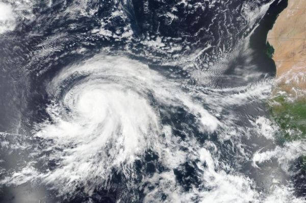
NASA-NOAA’s Suomi NPP satellite provided a full visible image of a strengthening Hurricane Lorenzo in the eastern North Atlantic Ocean. On Sept. 26, Lorenzo attained status as a major hurricane.
NASA-NOAA’s Suomi NPP satellite provided a full visible image of a strengthening Hurricane Lorenzo in the eastern North Atlantic Ocean. On Sept. 26, Lorenzo attained status as a major hurricane.
A major hurricane is one that is a Category 3 or higher on the Saffir-Simpson Hurricane Wind Scale.
The Visible Infrared Imaging Radiometer Suite (VIIRS) instrument aboard Suomi NPP provided a visible image of the storm on Sept. 25. The VIIRS image showed powerful thunderstorms circling the center of Lorenzo with thick bands of thunderstorms wrapping into the low-level center from the south and east of center. The satellite imagery revealed that Lorenzo was getting better organized as it was strengthening. By 11 p.m. EDT, infrared imagery showed a small eye had been appearing intermittently.
The shape of the storm is a clue to forecasters that a storm is either strengthening or weakening. If a storm takes on a more rounded shape it is getting more organized and strengthening. Conversely, if it becomes less rounded or elongated, it is a sign the storm is weakening.
Read more at: NASA/Goddard Space Flight Center
On Sept. 25, the VIIRS instrument aboard NASA-NOAA's Suomi NPP satellite provided a visible image of Hurricane Lorenzo in the eastern North Atlantic Ocean. The African continent is east (right) in the image. (Photo Credit: NASA/NRL)


