
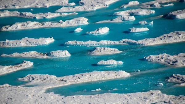
More than 65,000 meltwater lakes have been discovered on the edge of the East Antarctic Ice Sheet by our researchers.
More than 65,000 meltwater lakes have been discovered on the edge of the East Antarctic Ice Sheet by our researchers.
The number of these lakes, identified using high-resolution satellite images, is more significant than previously thought.
The satellite images covered five million square kilometres of the ice sheet – the world’s largest ice mass.
The research shows that meltwater lakes are forming in most coastal areas of the ice sheet, suggesting that some regions could be more sensitive to the effects of a warming climate than previously thought.
Researchers studied satellite images taken during the East Antarctic Ice Sheet’s summer melt season in January 2017 when meltwater lakes normally form.
The images showed that lakes often clustered just a few kilometres from where the ice sheet begins to float on the sea, but some can exist hundreds of kilometres inland and at heights of up to 1,000m.
Read more at: Durham University
Meltwater on the ice shelf next to McMurdo Station. (Photo Credit: Nicholas Bayou, UNAVCO.)


