
Over the weekend of Sept. 28 and 29, Hurricane Lorenzo attained Category 5 strength briefly, becoming the strongest hurricane on record in the eastern-most Atlantic Ocean.
Over the weekend of Sept. 28 and 29, Hurricane Lorenzo attained Category 5 strength briefly, becoming the strongest hurricane on record in the eastern-most Atlantic Ocean. Lorenzo has also attained and contributed to some other significant statistics. NASA-NOAA’s Suomi NPP satellite provided infrared data over two days provided forecasters with changes in the storm’s eye, powerful thunderstorms and gravity waves it was creating.
Record Setting
On Saturday, Sept. 28, when Lorenzo attained Category 5 (Cat 5) strength on the Saffir-Simpson Hurricane Wind Scale it was in a place more than 600 miles east-northeast of the previous record Cat 5 storm. It also had the lowest air pressure east of 50 degrees west longitude when the pressure dropped to 925 millibars.
There have been 26 Category 5 storms since 1960. Hurricane Camille was the first and Lorenzo is the latest. Over the past 3 years, six storms attained that level of intensity. The others include Dorian, Michael, Maria, Irma and Matthew. Earlier this year Dorian reached Category 5 strength, so this year joins only six other years that contained more than one Cat 5 storm since records began. Other years with more than one Cat 5 storm include 1932, 1933, 1961, 2005, 2007 and 2017.
Read more at NASA / Goddard Space Flight Center
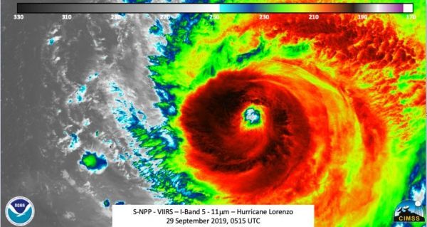
Image: The Suomi NPP satellite passed over the eastern Atlantic Ocean on Sept. 29, after Lorenzo weakened back to a Category 4 hurricane. The eye was well defined and there were mesovorticies seen. The strength of the storm also was producing mesospheric gravity waves. Credit: NASA/NOAA/UWM-CIMSS, William Straka


