
Hurricane Lorenzo was heading toward the Azores Islands when NASA-NOAA’s Suomi NPP satellite provided forecasters with an image of the storm.
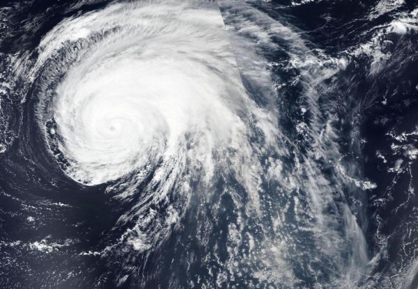
Hurricane Lorenzo was heading toward the Azores Islands when NASA-NOAA’s Suomi NPP satellite provided forecasters with an image of the storm. Satellite imagery revealed the large extent of the storm.
Visible imagery from NASA satellites help forecasters understand if a storm is organizing or weakening. The shape of a tropical cyclone provides forecasters with an idea of its organization and strength. The more circular a storm appears, the stronger it can be. The Visible Infrared Imaging Radiometer Suite (VIIRS) instrument aboard Suomi NPP provided a visible image of Lorenzo on Sept. 30 and revealed that Lorenzo has grown in size. In fact, it took two orbits of NASA-NOAA’s Suomi NPP satellite to capture the entire storm. Those two images were stitched together using the NASA Worldview, Earth Observing System Data and Information System (EOSDIS) at NASA’s Goddard Space Flight Center in Greenbelt, Md.
In the VIIRS imagery, Lorenzo’s eye had become less distinct on satellite images over Sept. 30 and Oct. 1, but the system remains very well organized with tightly curved convective bands.
Lorenzo is a very large tropical cyclone. NOAA’s National Hurricane Center or NHC noted that hurricane-force winds extend outward up to 90 miles (150 km) from the center and tropical storm-force winds extend outward up to 345 miles (555 km).
Read more at NASA/Goddard Space Flight Center
Image: NASA-NOAA's Suomi NPP satellite passed over Hurricane Lorenzo twice in the Northeastern Atlantic Ocean to obtain a full picture, stitched together, of the large storm. (Credit: NASA Worldview, Earth Observing System Data and Information System (EOSDIS))


