
The bulk of Typhoon Mitag’s clouds and precipitation has been pushed north of its center, extending its reach over the East China Sea.
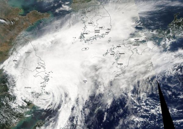
The bulk of Typhoon Mitag’s clouds and precipitation has been pushed north of its center, extending its reach over the East China Sea. Mitag was centered just off the coast of China’s Zhejiang province when NASA-NOAA’s Suomi NPP satellite passed overhead, but the bulk of the clouds were pushed north of center to the Korean Peninsula and southern Japan.
The Visible Infrared Imaging Radiometer Suite (VIIRS) instrument aboard Suomi NPP provided a visible image of Mitag on Oct. 1, showing its eye was just off the coast of China’s Zhejiang province in the East China Sea. The VIIRS image revealed some bands of thunderstorms wrapped around the partially-exposed, ragged low-level center of circulation off the China coast.
The main area of deep convection (rising air that forms thunderstorms that make up a tropical cyclone) and thunderstorms is located north of center and had decoupled from the center. That decoupled area of storms extended northeast to the Korean Peninsula and to Kyushu, the southwestern most of Japan’s main islands.
Read more at NASA / Goddard Space Flight Center
Image: NASA-NOAA’s Suomi NPP satellite passed over Typhoon Mitag in the East China Sea just off the coast of China’s Zhejiang province. The image showed Mitag’s northern reach extended to the Korean peninsula and southern Japan. Credit: NASA Worldview, Earth Observing System Data and Information System (EOSDIS)


