
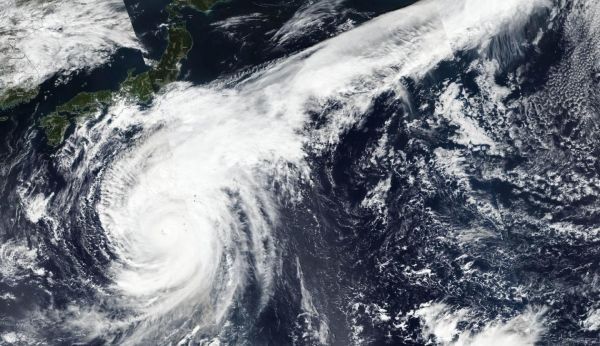
NASA-NOAA’s Suomi NPP satellite provided forecasters with a composite visible image of the very large Super Typhoon Hagibis in the Northwestern Pacific Ocean on Oct. 10.
NASA-NOAA’s Suomi NPP satellite provided forecasters with a composite visible image of the very large Super Typhoon Hagibis in the Northwestern Pacific Ocean on Oct. 10. It took Suomi NPP three orbits to capture images to show the entire storm that revealed it maintained its impressive structure.
Visible imagery from NASA satellites help forecasters understand if a storm is organizing or weakening, based on changes to its structure. The Visible Infrared Imaging Radiometer Suite (VIIRS) instrument aboard Suomi NPP provided three visible images of Hagibis on Oct. 10. Those images had to be stitched together to show the entire storm on NASA Worldview, the Earth Observing System Data and Information System (EOSDIS) data product at NASA’s Goddard Space Flight Center in Greenbelt, Md. The image showed an eye surrounded by powerful thunderstorms and a large “tail” of clouds streaming to the northeast of the center.
At 5 a.m. EDT (0900 UTC), NHC reported the center of Super Typhoon Hagibis was located near latitude 24.4 degrees north and longitude139.4 degrees east. Hagibis is about 654 miles (560 km) south of Yokosuka, Japan. Hagibis is moving toward the north-northwest. Maximum sustained winds are near 161 mph (259 kph/140 knots) with higher gusts.
Read more at NASA/Goddard Space Flight Center
Image: NASA-NOAA's Suomi NPP satellite passed over Super Typhoon Hagibis and revealed the storm maintaining an eye surrounded by powerful thunderstorms, and a large "tail" of clouds streaming to the northeast of the center. (Credit: NASA Worldview, Earth Observing System Data and Information System (EOSDIS))


