
Satellite data has confirmed the formation of Subtropical Storm Melissa.
Satellite data has confirmed the formation of Subtropical Storm Melissa. NASA’s Terra Satellite provided a visible image the former Nor’easter turned subtropical storm off the coast of New England.
The National Hurricane Center or NHC noted that the Nor’easter centered southeast of New England (in the northeastern U.S.) becomes a subtropical storm, and that the change in storm status does not change expected impacts from wind and coastal flooding along portions of the mid-Atlantic coast and Southeastern New England.
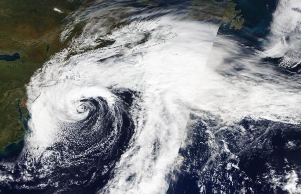
On Oct. 11, the Moderate Imaging Spectroradiometer or MODIS instrument that flies aboard NASA’s Terra satellite provided a visible image of the newly developed Melissa. Forecasters at the National Hurricane Center noted on Oct.11 at 11 a.m. EDT, “Convection increased near the center of the nor’easter centered southeast of New England overnight. First-light visible satellite imagery briefly showed an eye-like feature before the convection around the immediate center began to weaken. However, a large convective band still persists over the northern semicircle, and this structure indicated the system has transitioned to a subtropical cyclone.”
Read more at NASA / Goddard Space Flight Center
Image: On Oct. 11, the MODIS instrument that flies aboard NASA’s Terra provided a visible image of Subtropical Storm Melissa off the New England coast. Credit: NASA Worldview, Earth Observing System Data and Information System (EOSDIS).


