
NASA-NOAA’s Suomi NPP satellite passed over the Gulf of Mexico and revealed that a low pressure area was developing into a depression.
NASA-NOAA’s Suomi NPP satellite passed over the Gulf of Mexico and revealed that a low pressure area was developing into a depression. On Oct. 25, that low pressure area became Tropical Depression 17.
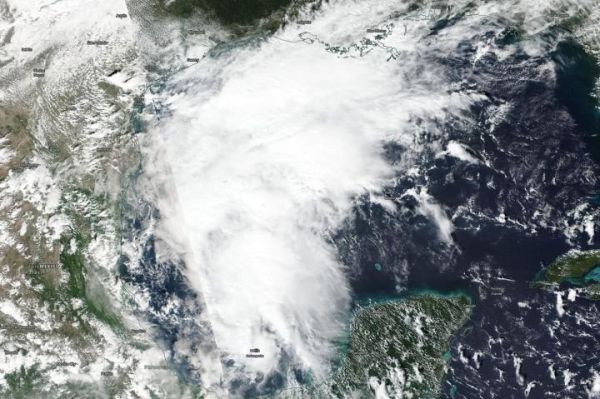
On Oct. 24, the Visible Infrared Imaging Radiometer Suite (VIIRS) instrument aboard NASA-NOAA’s Suomi NPP satellite captured a visible image of the structure of the low pressure area that became Tropical Depression 17 on Oct. 25. The storm appeared elongated from south to north, but the center was actually located west of all of the clouds and showers. In satellite imagery on Oct. 25, the National Hurricane Center said, “Satellite imagery indicates that the low pressure system in the western Gulf of Mexico has developed a well-defined circulation. In addition, a cluster of strong convection is located near and to the northeast of the low-level center.”
At 11 a.m. EDT (1500 UTC) on Oct. 25, the center of Tropical Depression 17 was located near latitude 25.6 degrees north and longitude 94.4 degrees west. That puts the center about 320 miles (515 km) south-southwest of Lake Charles, Louisiana.
Read More at: NASA/Goddard Space Flight Center
NASA-NOAA's Suomi NPP satellite passed over the Gulf of Mexico and the VIIRS instrument aboard captured this image of developing Tropical Depression 17 on Oct. 24, 2019. Suomi NPP showed that the center of circulation was west of the bulk of clouds. (Photo Credit: NASA/NOAA/NRL)


