
Tropical Storm Kyarr formed near the southwestern coast of India, and NASA’s Aqua satellite provided forecasters with a visible image of the storm that revealed it organized quickly.
Tropical Storm Kyarr formed near the southwestern coast of India, and NASA’s Aqua satellite provided forecasters with a visible image of the storm that revealed it organized quickly.
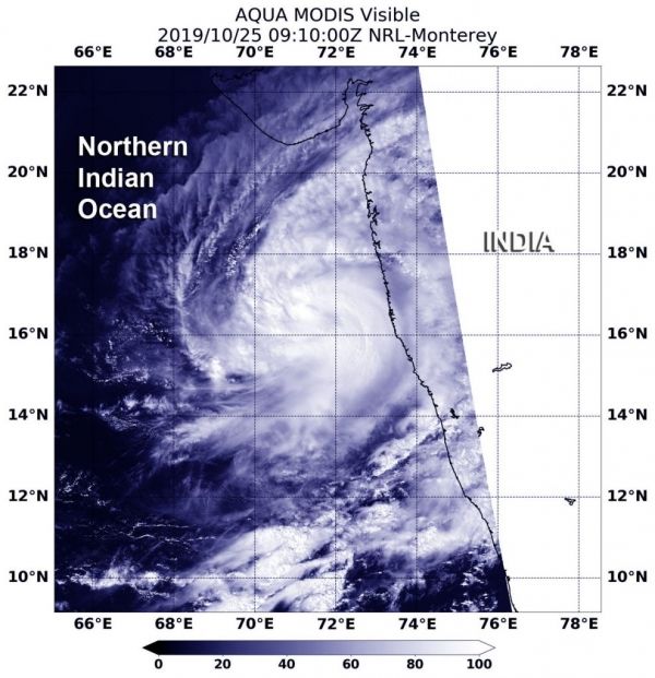
Kyarr formed early on Oct. 25 from a low-pressure area designated as System 97A in the northern Indian Ocean. Once the storm consolidated, it intensified quickly and became a tropical storm just off the southwest India coast.
The India Meteorological Department issued some warnings on Kyarr on Oct. 25. There is a heavy rainfall warning in effect that calls for light to moderate rainfall in most places. Heavy to very heavy falls are predicted at isolated places very likely over coastal districts of Karnataka, Goa and south Konkan and isolated heavy rainfall over north Konkan during next 24 hours. There is also a wind warning in effect calling for gale-force winds with speeds reaching 70-80 kph (43 to 50 mph) gusting to 90 kph (56 mph), prevailing around the system center over east-central Arabian Sea. It is very likely to increase gradually becoming 90-100 kph (56 to 62 mph).
Read more at NASA / Goddard Space Flight Center
Image: On Oct. 25 at 5:10 a.m. EDT (0910 UTC), the MODIS instrument that flies aboard NASA’s Aqua satellite took this image of Tropical Storm Kyarr off the coast of southwestern India. Credit: NASA/NRL


