
Tropical Storm Maha has developed near the coastline of southwestern India and NASA’s Terra satellite provided forecasters with a visible image of the storm.
Tropical Storm Maha has developed near the coastline of southwestern India and NASA’s Terra satellite provided forecasters with a visible image of the storm.
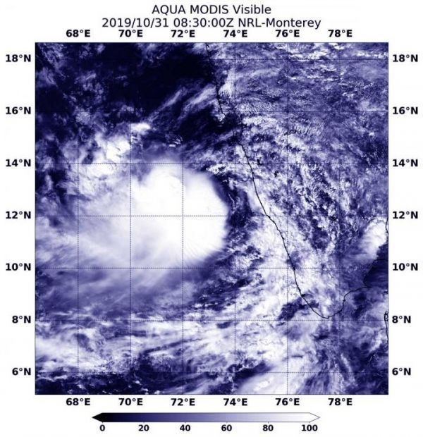
On Oct. 31 at 4:30 a.m. EDT (0830 UTC), the Moderate Imaging Spectroradiometer or MODIS instrument that flies aboard NASA’s Aqua satellite provided a visible image of Maha. The image showed Maha was off the coast of southwestern India. The storm also appeared somewhat elongated so it is still in the process of consolidating and strengthening.
The shape of the storm is a clue to forecasters that a storm is either strengthening or weakening. If a storm takes on a more rounded shape it is getting more organized and strengthening. Conversely, if it becomes less rounded or elongated, it is a sign the storm is weakening. Maha has appeared to become more symmetrical in the MODIS imagery on Oct. 31, indicating it had become better organized.
At 5 a.m. EDT (0900 UTC) on Oct. 31, the center of Tropical Storm Maha was located near latitude 11.9 degrees north and longitude 73.1 degrees east. That puts the center about 848 nautical miles south-southeast of Karachi, Pakistan, and just west of the southern tip of India. Maximum sustained winds were near 60 knots (69 mph/111 kph).
Read more at NASA/Goddard Space Flight Center
Image: On Oct. 31 at 4:30 a.m. EDT (0830 UTC), the MODIS instrument that flies aboard NASA's Aqua satellite took this image of Tropical Storm Maha just off the coast of southwestern India. (Credit: NASA Worldview)


