
Tropical Storm Fengshen continued to strengthen in the Northwestern Pacific Ocean as NASA’s Terra satellite passed overhead.
Tropical Storm Fengshen continued to strengthen in the Northwestern Pacific Ocean as NASA’s Terra satellite passed overhead. Infrared imagery from an instrument aboard Terra revealed very high, powerful storms with very cold cloud top temperatures circling the center.
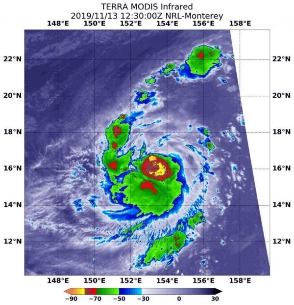
Tropical cyclones are made of up hundreds of thunderstorms, and infrared data can show where the strongest storms are located. They can do that because infrared data provides temperature information, and the strongest thunderstorms that reach highest into the atmosphere have the coldest cloud top temperatures.
On Nov. 13 at 7:30 a.m. EST (1230 UTC), the Moderate Imaging Spectroradiometer or MODIS instrument that flies aboard NASA’s Terra satellite used infrared light to analyze the strength of storms within the tropical cyclone. MODIS found those strongest storms in a very large area stretching from east to south of the center of circulation. In that quadrant cloud top temperatures were as cold as or colder than minus 80 degrees Fahrenheit (minus 62.2 Celsius). NASA research has found that cloud top temperatures that cold indicate strong storms with the potential to generate heavy rainfall. Powerful thunderstorms also circled that area and the entire center of circulation and in a fragmented band extending north of center.
Read more at: NASA/Goddard Space Flight Center
On Nov. 13 at 7:30 a.m. EST (1230 UTC), the MODIS instrument that flies aboard NASA’s Terra satellite showed strongest thunderstorms with coldest cloud top temperatures (yellow) in a very large area from east to south of the center of circulation, where cloud top temperatures were as cold as or colder than minus 80 degrees Fahrenheit (minus 62.2 Celsius). (Photo Credit: NASA/NRL)


