
NASA-NOAA’s Suomi NPP satellite passed over Tropical Storm Kammuri in the Northwestern Pacific Ocean and found several areas of very strong thunderstorms.
NASA-NOAA’s Suomi NPP satellite passed over Tropical Storm Kammuri in the Northwestern Pacific Ocean and found several areas of very strong thunderstorms.
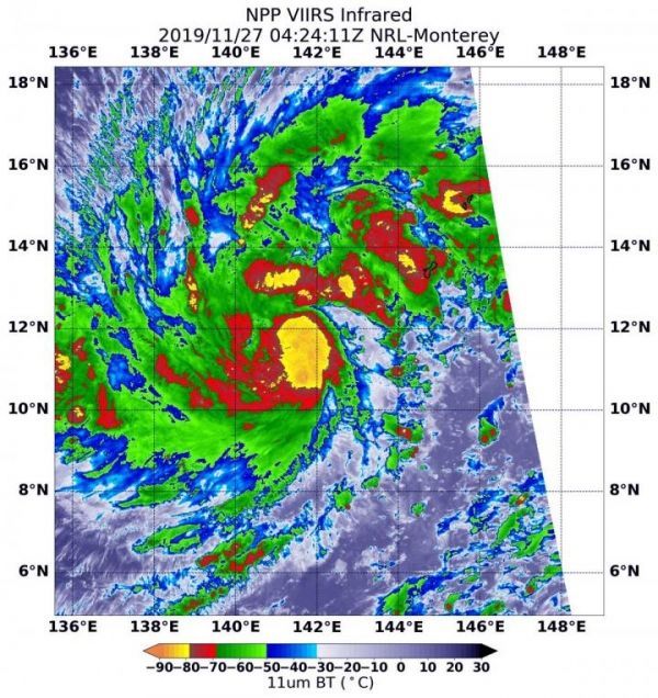
The Visible Infrared Imaging Radiometer Suite (VIIRS) instrument aboard Suomi NPP provided an infrared image of the storm on Nov. 27 at 0424 UTC (Nov. 26 at 11:24 p.m. EST). Infrared imagery reveals cloud top temperatures, and the higher the cloud top, the colder it is, and the stronger the storm.
The VIIRS instrument found several areas within where cloud top temperatures were as cold as minus 80 degrees Fahrenheit (minus 62.2 Celsius), indicating powerful storms. Kammuri continued to strengthen and consolidate. The most powerful thunderstorms were located around the center of circulation and in a fragmented band of thunderstorms north of the center. Storms with cloud tops that cold have been found to generate heavy rainfall.
Read more at: NASA/Goddard Space Flight Center
NASA-NOAA's Suomi NPP satellite passed over Tropical Storm Kammuri in the Northwestern Pacific Ocean and the VIIRS instrument aboard captured this image of the storm on Nov. 27 at 0424 UTC (Nov. 26 at 11:24 p.m. EST). There were several areas (yellow) within where cloud top temperatures were as cold as minus 80 degrees Fahrenheit (minus 62.2 Celsius), indicating powerful storms. (Photo Credit: NASA/NRL)


