
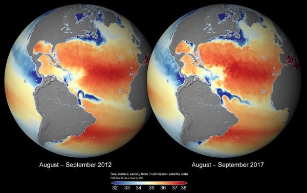
Since the saltiness of ocean surface waters is a key variable in the climate system, understanding how this changes is important to understanding climate change. Thanks to ESA’s Climate Change Initiative, scientists now have better insight into sea-surface salinity with the most complete global dataset ever produced from space.
If you’re a keen sea-swimmer, you may have noticed that the water can be saltier in some places than others. This is because the saltiness of the water depends on nearby additions of freshwater from rivers, rain, glaciers or ice sheets, or on the removal of water by evaporation.
The salinity of the ocean surface can be monitored from space using satellites to give a global view of the variable patterns of sea-surface salinity across the oceans.
Unusual salinity levels may indicate the onset of extreme climate events, such as El Niño. Global maps of sea-surface salinity are particularly helpful for studying the water cycle, ocean–atmosphere exchanges and ocean circulation, which are all vital components of the climate system transporting heat, momentum, carbon and nutrients around the globe.
A new and ongoing project for ESA’s Climate Change Initiative (CCI) – a research programme dedicated to generating accurate and long-term datasets for 21 Essential Climate Variables, required by the United Nations Framework Convention on Climate Change and the Intergovernmental Panel on Climate Change – has generated the most complete global dataset of sea-surface salinity from space to date.
Continue reading at European Space Agency
Image via European Space Agency


