
Satellite remote sensing has widely been used to monitor and characterize the spatial and temporal changes of the Earth’s vegetative cover.
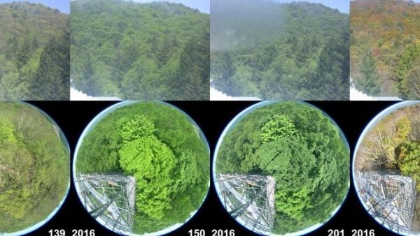
Environmental scientists are always in search of new tools that can better characterize the Earth’s surface. In a new study published in Scientific Reports, a team of researchers in the U.S. and Japan, led by a University of Hawaiʻi at Mānoa professor, reported a new-generation geostationary satellite was able to capture the seasonal changes of vegetation in central Japan more accurately than before.
Under the leadership of Tomoaki Miura, from the College of Tropical Agriculture and Human Resources’ Department of Natural Resources and Environmental Management, researchers including Shin Nagai and Mika Takeuchi from Japan Agency for Marine-Earth Science and Technology, Kazuhito Ichii from Chiba University, and Hiroki Yoshioka from Aichi Prefectural University, found that Himawari-8’s Advanced Himawari Imager (AHI) acquired approximately 26 times more observations than one of the latest polar-orbiting satellite sensors, for the year 2016. As a result, there were a larger number of days with “cloud-free” observations with Himawari-8 AHI.
“Detailed vegetation seasonal information from the Himawari-8 geostationary satellite can be useful for many applications such as short-term drought monitoring and assessing the impact of heavy rainfall events,” said Miura. It is expected that AHI geostationary sensor data would contribute to improving understanding of vegetation dynamics and the effect of climate change in the cloud-prone tropical region.
Continue reading at University of Hawaiʻi at Mānoa
Image via University of Hawaiʻi at Mānoa


