
NASA-NOAA’s Suomi NPP satellite provided forecasters with an image of Tropical Cyclone Sarai and it showed a much weaker storm near Tonga in the South Pacific Ocean.
NASA-NOAA’s Suomi NPP satellite provided forecasters with an image of Tropical Cyclone Sarai and it showed a much weaker storm near Tonga in the South Pacific Ocean.
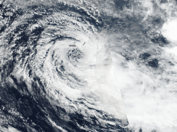
Visible imagery from NASA satellites help forecasters understand if a storm is organizing or weakening. The Visible Infrared Imaging Radiometer Suite (VIIRS) instrument aboard Suomi NPP provided a visible image of Sarai on Dec. 31.
The shape of a tropical cyclone provides forecasters with an idea of its organization and strength, and NASA-NOAA’s Suomi NPP satellite provided a visible image of Sarai that showed the center of circulation was surrounded by wispy clouds, while the bulk of clouds and showers were pushed to the southeast of the center from outside winds or vertical wind shear. Because the center of circulation was near Tonga, Regional warnings were still in effect for Tonga. A gale warning is in force for Vava’u, Ha’apai, Tongatapu and ‘Eua land areas.
Read more at NASA / Goddard Space Flight Center
Image: NASA-NOAA’s Suomi NPP satellite provided forecasters with a visible image of Tropical Depression Sarai near the island of Tonga in the South Pacific Ocean. Credit: NASA Worldview, Earth Observing System Data and Information System (EOSDIS)


