
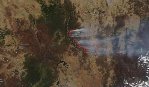
NASA's Terra satellite saw yet another fire, known as the Orroral Valley Fire, break out in the Canberra region of Australia, specifically in and around the Namadgi National Park.
NASA's Terra satellite saw yet another fire, known as the Orroral Valley Fire, break out in the Canberra region of Australia, specifically in and around the Namadgi National Park. In one week, these fires have consumed 62,988 hectares (155,646 acres) according to the Australian Capital Territory Emergency Services Agency as of Feb. 04, 2020 (2:30 am local Australian time). The Department of Defence in Australia has reported that a firefighting helicopter's landing lights created the heat needed to spark the new fire. Since the area is tinder-dry, any bit of heat can provide the ignition for a new blaze. Below is a sliding image showing the true- and false-color images of the fire on Feb. 03, 2020 taken by the Terra satellite using the MODIS (Moderate Resolution Imaging Spectroradiometer) instrument. The dark red-brown color represents areas where the fires have burned the land.
NASA/NOAA's Suomi NPP satellite also captured an image of the fires using their Day/Night band on the VIIRS (Visible Infrared Imaging Radiometer Suite) instrument. At night the fires can clearly be seen in this image from February 02, 2020. The fire line of the new blaze is extremely close to the city of Canberra, the capital of Australia. This area is under a State of Emergency until at least Sunday. Fire crews have, to date, been able to save all structures in the Australian Capital Territory.
Read more at NASA/Goddard Space Flight Center
Image: The image shows a true-color image from the Terra satellite on Jan. 03, 2020. (Credit: NASA)


