
When NASA’s Aqua satellite passed over the Southern Indian Ocean on Feb. 7, it gathered water vapor data that provided information about the intensity of Tropical Cyclone Damien.
When NASA’s Aqua satellite passed over the Southern Indian Ocean on Feb. 7, it gathered water vapor data that provided information about the intensity of Tropical Cyclone Damien.
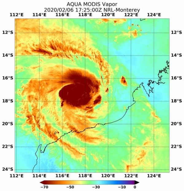
On Feb. 7 at 12:25 a.m. EST (1725 UTC), NASA’s Aqua satellite passed over Tropical Cyclone Damien, located in the Southern Indian Ocean and off Australia’s Pilbara coast. Aqua found highest concentrations of water vapor (brown) and coldest cloud top temperatures were around the center. Credits: NASA/NRLThe Australian Bureau of Meteorology (ABM) issued warnings and watches as Tropical Cyclone Damien moves toward the Pilbara Coast of Western Australia.
On Friday, February 7 at 11:46 pm WST (10:46 a.m. EST), the Warning Zone extends from Pardoo to Onslow, including Port Hedland, Karratha, Dampier, Pannawonica and Barrow Island and extending to adjacent inland parts to include Marble Bar, Tom Price and Paraburdoo. The Watch Zone includes inland central Pilbara including Nullagine, Newman and Mt Augustus.
Read more at NASA / Goddard Space Flight Center
Image: On Feb. 7 at 12:25 a.m. EST (1725 UTC), NASA’s Aqua satellite passed over Tropical Cyclone Damien, located in the Southern Indian Ocean and off Australia’s Pilbara coast. Aqua found highest concentrations of water vapor (brown) and coldest cloud top temperatures were around the center. Credits: NASA/NRL


